

Utilizing simple software to meet your farm’s goals
I began designing urban and suburban landscape in 2006 using pen and paper. I specialized in native plants, natural stonework and edible gardens. I received my Permaculture Design Certificate a couple of years later and began to design larger landscapes, transitioning to planning rural and farm landscapes in 2011. In that timeframe, I began to use GIS (Geographic Information Systems) and learned how to connect data to geography.
I’ve worked with many landowners to find out what actually helps them reach their goals in a land plan. Ultimately, the practical work of land planning generally involves delineating crop areas, pasture, conservation land, watershed restoration practices and more. Using GIS for this work is highly efficient and beneficial — once the initial learning curve is overcome.
In permaculture design there are a lot of designers approaching the craft of land planning with very new and inexperienced eyes. This can be good, in terms of bringing a fresh perspective to the table, but fanciful ideas can be divorced from day-to-day reality. After many years working with landowners, I’ve come to realize that first and foremost, landowners are looking for a comprehensive understanding of the land they own, as well as its context within their region.
Using GIS, landowners can understand the ecological functions and elements of their landscape and can place the elements they desire to incorporate, such as crops and livestock, in beneficial relationship to one another on the landscape. This is really the essential function of a land planner.

In general, there are two types of landowners: those who want to create a permaculture homestead — what many people would consider a hobby farm — and those who want to pursue large-scale farming, ranching or conservation. Each has unique land planning needs that can be assisted through the judicious use of GIS.
Homesteaders are usually looking for detailed plans around the home and garden. They might be interested in pollinator plantings and water features. They want to utilize their resources mostly for sustenance and survival. Large-scale farmers usually look for ways to increase production, lower costs and understand the flows of energy through their landscape. They want to utilize their resources for profit.
These two types of landowners have similar and overlapping goals, but they are focused on different “Zones of Use,” which is a permaculture term meaning delineation of a landscape into areas based on time spent within them. For instance, Zone 0 is the home and Zone 1 is the area around the home, in which we spend the most outdoor time. The design methodology of permaculture recommends putting our vegetable gardens in Zone 1, with orchards and poultry in Zone 2. For a thorough treatment on zone functionality, refer to Edible Forest Gardens by Jacke and Toensmeier.
Zones are a great way to think about energy flows through a landscape. I’ve worked with landscape architects and civil engineers, and most of the time they have been trained to focus on the practical solutions to certain landscape problems, whereas permaculture designers and land planners are tasked with looking at the overall patterns and bigger picture. Using GIS helps us understand the patches and corridors that make up our landscape. We can then design to the needs of our existing ecologies.
There are several online courses a designer can take to learn how to do computer-aided permaculture design, or regenerative land-planning, such as keyline design or Holistic Management. But nothing supersedes experience. I’ve also learned that though many landowners would like to design their own landscape, they often don’t have the necessary training or computer skills to do so.
My tried-and-true system utilizes GIS — as opposed to many landscape architects or designers who use Adobe Illustrator or AutoCAD. To me, GIS makes the most sense, as it is a technology that has been developed over decades to work with geographic information. This is what we should be working with when we create a land plan.

QGIS is the premier free and open-source GIS software platform (“open source” means that the source code is freely available and can be modified as desired). ArcGIS is the fancy commercial version that requires a monthly payment with several tiers to choose from. Most people I know using ArcGIS are in larger organizations, as it requires a significant investment. QGIS, on the other hand, is growing in popularity and usage across industry and is definitely all that is necessary for simple land plans — and then some.
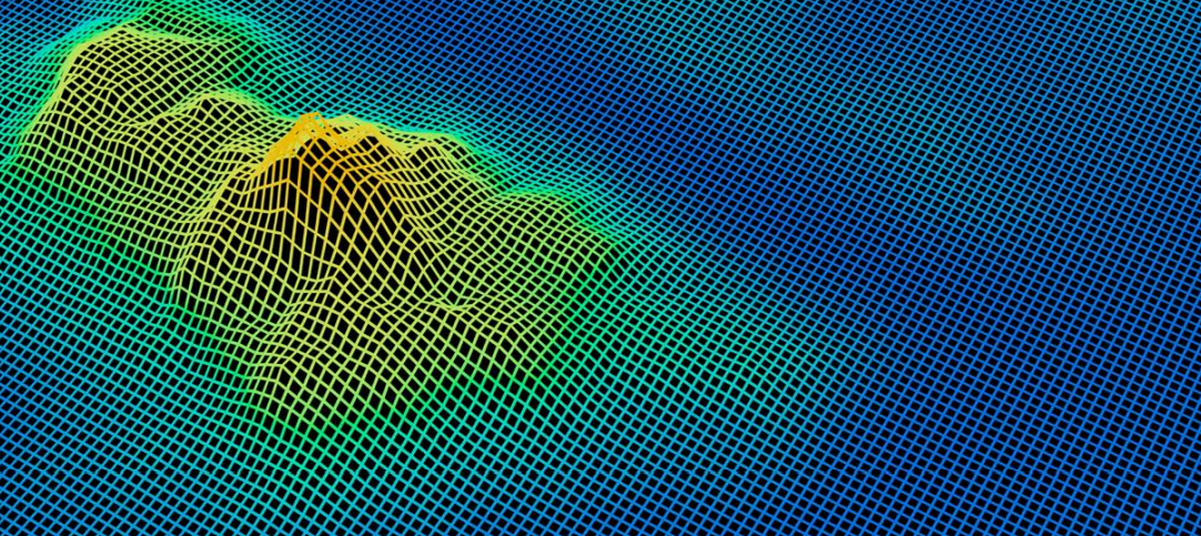
Using moderately inexpensive drones, a land planner or land owner can take photographs of their current landscape and assemble them into what is called orthoimagery — a georeferenced mosaic image that you can then bring into GIS to analyze and use as a base map for a design. We can also use that imagery to learn more about plant health in our fields and pastures. Some special drone cameras can pick up infrared light for an even more accurate assessment of crop health. Using special software, such as Drone Deploy, we can take our orthoimagery and create three-dimensional models, called aerial photogrammetry. Lidar (light detection and ranging), which is like land-based radar but from planes, can shoot lasers at the surface of the earth to create accurate models of everything on and above the ground — from trees and their leaves to buildings and electric utility lines.
All of this georeferenced data can be brought into GIS for analysis and used for land planning. If we use Illustrator or some other graphics program, we do not have a way to work with georeferenced data or further analyze it. This is the greatest advantage of GIS.
One of the most important subjects in land planning and analysis is the flow of water on and over the land surface. Topography is a big issue when considering wind power generation or solar electric panel orientation. There are many lidar resources provided by local and national governments; many are available in the U.S. at the National Map website. We can use this crucial data to understand the geomorphology of our landscape and the surrounding region. Using GIS, we can quickly deduce how solar, wind and water energy flow through the landscape.
Here in the U.S., the Natural Resources Conservation Service (NRCS), a branch of the USDA, has mapped almost all of our soils in the country and created detailed soil surveys that provide great baseline data on the soil types in our land plans — information that can help determine which crops might grow best. Soil data can be brought into GIS for land planning purposes; this is a large basis of NRCS planning. As an NRCS Technical Service Provider, I know that the programs used to calculate soil conservation for agricultural landscapes are heavily reliant on soil survey data.
Using satellite imagery or drone orthoimagery, we can also map out the general types of ground cover across our landscapes and region. This helps us understand the energy flows of wild animal species through the landscape. Mapping and designing wildlife corridors is a highly GIS-dependent science and is becoming more desired and utilized as the public understands the importance of wild species in the ecosystem. We can also map out riparian buffer zones and plan conservation plantings alongside our streams and riverine landscapes.
Most farmers I know use spreadsheets of some sort to plan their seasonal crops. An incredibly useful and underutilized function of GIS is that we can connect our spreadsheets with our spatial crop plans in our GIS projects and can include plant productivity and health data as we collect it. Time is a function of space as well, and we can collect this data and store it in spreadsheets or databases to see how productive each of our fields or pastures actually is, in a scientific manner.
I don’t believe that there is anything wrong with hand-drawn crop layouts or spreadsheet crop plans, or even back-of-the-invoice scrawled production notes. But what if we could bring all of this data together in one place and derive impactful insight from it?
Most of us don’t have a lot of extra time to learn how to draw or draft plans, and even if we created the most beautiful design in the world, it would be difficult to alter. One thing I’ve learned as a land planner is that plans change as goals evolve. With a digital plan, we can make a design change in minutes without much hassle.
Andrew French is a land planner and GIS analyst for the NRCS and for Midwest landowners. He also owns and operates Full Boar Farm in Boyceville, Wisconsin. Learn more about his land planning services and resources at andrewrfrench.com.


